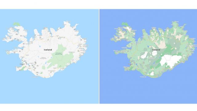
The overhaul will help users better distinguish between elements whether they are beaches, deserts, lakes or snow caps on the peaks of mountaintops, in what Google is calling “one of the most comprehensive views of natural features on any major map app”.
A new colour-mapping algorithmic technique is being used by the tech giant to make the service visually richer, capable of revealing a densely covered forest in dark green, while making an area of patchy shrubs a lighter shade of the colour.
Announcing new enhanced natural features in Google Maps Platform starting September 15. 🌱 Learn how you can preview the new greenery and enhanced vegetation → https://t.co/bFdGtCsYcu pic.twitter.com/Q4qGCUA7L9
— Google Maps Platform (@GMapsPlatform) August 18, 2020
The redesign will be available across all 220 countries and territories that Google Maps supports starting this week, “from the biggest metropolitan areas to small, rural towns”, the firm said.
A more detailed street view is also in the pipeline, which will start with London, New York, and San Francisco in the coming months.
This update will show the accurate shape and width of a road to scale, Google said, allowing people to see exactly where features like pavements, crossings and pedestrian islands are located.


