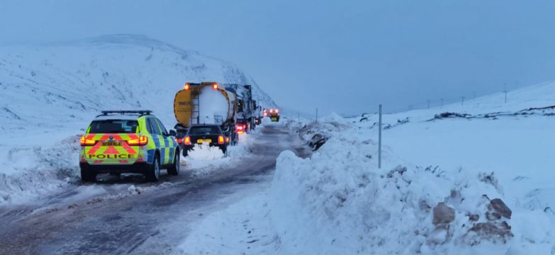
Drivers have been rescued after heavy snow saw vehicles become stranded overnight and buried roads in the north of Scotland.
Highland Council said emergency services are assisting the rescue operation after vehicles got trapped on the A835 between Ullapool and Garve.
It said around 20 vehicles had become stranded in snow at Loch Droma.
Here's dashcam footage of one of our spreaders clearing snow on the #A835 last night - snow drifts are over two metres deep in some places.
Road remans CLOSED between Garve & Ullapool and teams are working tirelessly to reopen the route as soon as possible. pic.twitter.com/8eQ49wAdnq— BEAR NW Trunk Roads (@NWTrunkRoads) February 5, 2021
Advertisement
Road management organisation Bear Scotland said the vehicles were caught in two-metre snow drifts and operations are ongoing.
The Scottish Fire and Rescue Service said it attended the Aultguish Inn on the A835 at about 5.15am on Friday to assist stranded drivers and passengers, and crews remain at the scene.
Network Rail said services have been disrupted on the Highland Mainline despite plough trains being used to clear snow.
It comes as a Met Office amber weather warning for snow is in place across large parts of Scotland until 6am on Saturday.
Elsewhere, Bear Scotland said the A85 is closed west of Methven in Perth and Kinross due to flooding caused by surface water and all vehicles except HGVs and buses are being diverted.
⚠️⚠️ A reminder that we still have in place an AMBER #snow warning across central and northern #Scotland ⚠️⚠️
Lots more information here 👉 https://t.co/QwDLMfRBfs
Stay #WeatherAware pic.twitter.com/54YKYfyYd2— Met Office (@metoffice) February 5, 2021
The amber weather warning covers Central, Tayside and Fife, Grampian, the Highlands and Islands and Argyll and Bute, warning the conditions could cause road and rail disruption, and power cuts.
It forecast 10-15cm of snow at low levels, with 20-30cm accumulating above about 150m.
A separate yellow warning forecasts periods of snow, heavy at times, for much of inland central and northern Scotland through Friday and into Saturday.
A further warning for snow and ice covers the length of Britain from midday on Saturday to midnight on Monday.
By next week, temperatures will be struggling to get much above 0C in quite a few places, with some areas such as the Pennines and high parts of Scotland seeing several degrees below that.
⚠️WEATHER WARNINGS⚠️
The @metoffice has issued an🔶 AMBER 🔶weather warning for SNOW until 06:00 Tomorrow
Yellow Warnings for SNOW & ICE also in place this week
More info 👉 https://t.co/11rOsqAy5J
Please only travel if it is essential#DriveSafe pic.twitter.com/gie3R3xbR0— Traffic Scotland (@trafficscotland) February 5, 2021
Birmingham faces lows of minus 2C by Tuesday morning, while a strong easterly wind will make it feel many degrees below freezing in some parts, according to Met Office forecaster Steven Keates.
He said it will be “really unpleasant” to be outdoors, adding: “If you do have to go outside there are lots of layers required, I think.”
Mr Keates said the south of Britain will see a “marked” drop in temperatures across Saturday and Sunday, with some parts possibly seeing 5-10cm of snow.
He said: “Enough snow is on the cards to cause potentially quite a bit of disruption in the south-east of England through Sunday, and potentially very early next week as well.”


