Hurricane Helene made landfall on Thursday in northwestern Florida as a Category 4 storm as forecasters warned of “catastrophic” flooding along the Gulf Coast.
The National Hurricane Centre in Miami said Helene roared ashore around 11.10pm local time near the mouth of the Aucilla River in the Big Bend area of Florida’s Gulf Coast. It had maximum sustained winds estimated at 140 mph (225 kph).
Officials have forecast storm surges of up to 20 feet (six metres) and warned they could be particularly “catastrophic and unsurvivable” in Florida’s Apalachee Bay.
Hurricane warnings and flash flood warnings extended far beyond the coast up into northern Georgia and western North Carolina.
Strong winds already cut power to nearly 900,000 homes and businesses in Florida, according to the tracking site poweroutage.us. The governors of Florida, Georgia, Alabama, the Carolinas and Virginia all declared emergencies in their states.
Catastrophic and life-threatening flash and urban flooding, including numerous significant landslides, is expected across portions of the southern Appalachians through Friday. Considerable to locally catastrophic flash and urban flooding is likely for northwestern and northern… pic.twitter.com/GA4HofEwpU
— National Weather Service (@NWS) September 27, 2024
Two people were reported killed in a possible tornado in south Georgia as the storm approached.
The National Weather Service in Tallahassee issued an “extreme wind warning” for the Big Bend as the eyewall approached: “Treat this warning like a tornado warning,” it said in a post on X. “Take shelter in the most interior room and hunker down!”
Helene arrives barely a year since Hurricane Idalia slammed into Florida’s Big Bend and caused widespread damage. Idalia became a Category 4 in the Gulf of Mexico but made landfall as a Category 3 near Keaton Beach, with maximum sustained winds near 125 mph (205 kph).
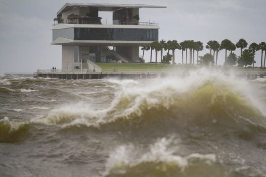
The storm’s wrath was felt widely, with sustained tropical storm-force winds and hurricane-force gusts along Florida’s west coast.
Water lapped over a road in Siesta Key near Sarasota and covered some intersections in St Pete Beach. Lumber and other debris from a fire in Cedar Key a week ago crashed ashore in the rising water.
Beyond Florida, up to 10 inches (25 centimetres) of rain had fallen in the North Carolina mountains, with up to 14 inches (36 centimetres) more possible before the deluge ends, setting the stage for flooding that forecasters warned could be worse than anything seen in the past century.
Heavy rains began falling and winds were picking up in Valdosta, Georgia, near the Florida state line. The weather service said more than a dozen Georgia counties could see hurricane-force winds exceeding 110 mph.
In south Georgia, two people were killed when a possible tornado struck a mobile home on Thursday night, Wheeler County Sheriff Randy Rigdon told WMAZ-TV. The damage was reported as heavy thunderstorms raked much of the state. Wheeler County is about 70 miles (113 kilometres) southeast of Macon.
Catastrophic hurricane-force winds are occurring near the coast within the eyewall of Helene and will spread inland over portions of northern Florida and southern Georgia. pic.twitter.com/nzozgWl51j
— National Weather Service (@NWS) September 27, 2024
Forecaster Dylan Lusk said the National Weather Service issued a tornado warning for Wheeler County at 8.47pm on Thursday. He said it is one of 12 tornado warnings the office near Atlanta issued for parts of Georgia between 1pm and 11pm.
Many were heeding the mandatory evacuation orders that stretched from the Panhandle south along the Gulf Coast in low-lying areas around Tallahassee, Gainesville, Cedar Key, Lake City, Tampa and Sarasota.
Among them was Sharonda Davis, one of several gathered at a Tallahassee shelter worried their mobile homes would not withstand the winds.
She said the hurricane’s size is “scarier than anything because it’s the aftermath that we’re going to have to face”.
Federal authorities were staging search-and-rescue teams as the weather service forecast storm surges of up to 20 feet (six metres) and warned they could be particularly “catastrophic and unsurvivable” in Apalachee Bay.
“Please, please, please take any evacuation orders seriously!” the office said, describing the surge scenario as “a nightmare”.
This stretch of Florida known as the Forgotten Coast has been largely spared by the widespread condo development and commercialisation that dominates so many of Florida’s beach communities. The region is loved for its natural wonders — the vast stretches of salt marshes, tidal pools and barrier islands.
“You live down here, you run the risk of losing everything to a bad storm,” said Anthony Godwin, 20, who lives about a half-mile (800 metres) from the water in the coastal town of Panacea, as he stopped for petrol before heading west towards his sister’s house in Pensacola.
School districts and multiple universities cancelled classes. Airports in Tampa, Tallahassee and Clearwater were closed on Thursday, while cancellations were widespread elsewhere in Florida and beyond.
While Helene will likely weaken as it moves inland, damaging winds and heavy rain were expected to extend to the southern Appalachian Mountains, where landslides were possible, forecasters said.
The hurricane centre warned that much of the region could experience prolonged power outages and flooding. Tennessee was among the states expected to get drenched.

Helene had swamped parts of Mexico’s Yucatan Peninsula on Wednesday, flooding streets and toppling trees as it passed offshore and brushed the resort city of Cancun.
In western Cuba, Helene knocked out power to more than 200,000 homes and businesses as it brushed past the island.
Areas 100 miles (160 kilometres) north of the Georgia-Florida line expected hurricane conditions. The state opened its parks to evacuees and their pets, including horses. Overnight curfews were imposed in many cities and counties in south Georgia.
“This is one of the biggest storms we’ve ever had,” said Georgia Governor Brian Kemp.
For Atlanta, Helene could be the worst strike on a major southern inland city in 35 years, said University of Georgia meteorology professor Marshall Shepherd.
Helene is the eighth named storm of the Atlantic hurricane season, which began on June 1. The National Oceanic and Atmospheric Administration has predicted an above-average Atlantic hurricane season this year because of record-warm ocean temperatures.
In further storm activity, Tropical Storm Isaac formed on Wednesday in the Atlantic and was expected to strengthen as it moves eastward across the open ocean, possibly becoming a hurricane by the end of the week, forecasters said.
Officials said its swells and winds could affect parts of Bermuda and eventually the Azores by the weekend.
In the Pacific, former Hurricane John reformed on Wednesday as a tropical storm and strengthened on Thursday back into a hurricane as it threatened areas of Mexico’s western coast with flash flooding and mudslides.
Mexico President Andres Manuel Lopez Obrador raised John’s death toll to five as communities along the country’s Pacific coast prepared for the storm to make a second landfall.


