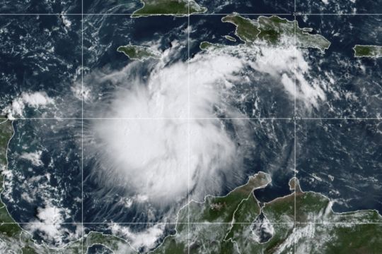
Hurricane Ian is growing stronger as it approaches the western tip of Cuba – on track to hit the west coast of Florida as a major hurricane as early as Wednesday.
Ian is forecast to hit Cuba and then become an even stronger category four hurricane with top winds of 140mph over warm Gulf of Mexico waters before striking Florida along a stretch of coast including the Tampa Bay area.
“Please treat this storm seriously. It’s the real deal. This is not a drill,” Hillsborough County emergency management director Timothy Dudley said at a Monday press conference on storm preparations in Tampa.
Governor DeSantis Delivers Update on Hurricane Ian https://t.co/pd4UKjeXwq
— Ron DeSantis (@GovRonDeSantis) September 26, 2022
Advertisement
Authorities in Cuba suspended classes in the Pinar del Rio province and planned evacuations as Ian gained strength on approach to Grand Cayman and the Cuban provinces of Isla de Juventud, Pinar del Rio and Artemisa.
Cuba was also shutting down its train system ahead of the worst weather.
“Cuba is expecting extreme hurricane force winds, also life threatening storm surge and heavy rainfall,” US National Hurricane Centre senior specialist Daniel Brown told the Associated Press early on Monday.
The path of Tropical Storm Ian remains uncertain and could have impacts from the Keys to Northwest Florida. Floridians along the Gulf Coast should prepare now for the possibility of severe weather next week.⁰
Follow @FLSERT for the most up-to-date information about the storm. pic.twitter.com/XNmOf8PPwP— Ron DeSantis (@GovRonDeSantis) September 25, 2022
Advertisement
By 11am EDT (4pm UK time) on Monday, Ian was moving north west at 13mph, about 240 miles south east of the western tip of Cuba, with top sustained winds increasing to 80mph.
As the hurricane approached the Cayman Islands, members of the government and opposition were working together “to ensure that our people are made as safe as possible – the supplies, plywood, in some cases sandbags, are distributed so that they can safely weather this storm,” Premier Wayne Panton said in a video posted on Sunday.
“We must prepare for the worst and absolutely pray and hope for the best.”
“Ian is not expected to spend much time over western Cuba, and additional strengthening is likely over the southeastern Gulf of Mexico on Tuesday,” the centre said.
“Ian is likely to have an expanding wind field and will be slowing down by that time, which will have the potential to produce significant wind and storm surge impacts along the west coast of Florida.”
A surge of up to 10 feet of ocean water and 10 inches of rain is predicted across the Tampa Bay area, with as much as 15 inches in isolated areas.
That is enough water to inundate low-lying coastal communities.
Florida residents are getting ready, lining up for hours in Tampa to collect bags of sand and clearing store shelves of bottled water.
As many as 300,000 people may be evacuated from low-lying areas in Hillsborough County alone, county administrator Bonnie Wise said.
In preparation for Tropical Storm #Ian, I directed @MyFDOT to waive weight restrictions for commercial trucks to ensure ample fuel and resources are coming into FL.
We've also waived state requirements to ensure pharmacies can prescribe 30-day emergency refills for medications.— Ron DeSantis (@GovRonDeSantis) September 25, 2022
Some of those evacuations were beginning on Monday afternoon in the most vulnerable areas, with schools and other locations opening as shelters.
“We must do everything we can to protect our residents. Time is of the essence,” Ms Wise said.
A hurricane watch has been issued for Florida’s central western coast including the Tampa Bay area, where Hillsborough County suspended classes until Friday to prepare schools to serve as shelters for evacuees.
Additional watches for more northern areas along the peninsula’s west coast may be issued, Mr Brown said.
Governor Ron DeSantis has declared a state of emergency throughout Florida and urged residents to prepare for the storm to lash large swaths of the state with heavy rains, high winds and rising seas.
US President Joe Biden also declared an emergency, authorising the Department of Homeland Security and the Federal Emergency Management Agency (Fema) to co-ordinate disaster relief and provide assistance to protect lives and property.
The President postponed a scheduled September 27 trip to Florida because of the storm.
Flash and urban flooding is predicted for much of the Florida peninsula midweek, and then heavy rainfall is possible for the south-east United States later this week.
With tropical storm force winds extending 115 miles from its centre, watches were issued Monday from the Florida Keys to Lake Okeechobee.
Wow — #Ian is RAPIDLY intensifying.
It has robust convection with very tall, cold cloud tops. Look at the Fibbionacci spiral… this thing will be a hurricane within a few hours, and could be near a major hurricane 30 hours from now.
A Caribbean monster is awakening. pic.twitter.com/Y4kETeGCyB— Matthew Cappucci (@MatthewCappucci) September 26, 2022
As of Monday, Tampa and St Petersburg appeared to be the among the most likely targets for their first direct hit by a major hurricane in a century.
Bob Gualtieri, sheriff of Pinellas County, Florida, which includes St Petersburg, said in a briefing that while no one will be forced to leave, “mandatory” evacuation orders are expected to begin on Tuesday.
“What it means is, we’re not going to come help you. If you don’t do it, you’re on your own,” Mr Gualtieri said.
The evacuation zone is all along Tampa Bay and the rivers that feed it, encompassing MacDill Air Force Base, Tampa International Airport and well-known neighbourhoods such as parts of Hyde Park, Davis Islands and Ybor City.
St Petersburg mayor Ken Welch urged residents not to ignore any evacuation orders.
“This is a very real threat that this storm poses to our community,” he said.
The hurricane centre has advised Floridians to have hurricane plans in place and monitor updates of the storm’s evolving path.


