The US Navy has ordered the USS Nimitz aircraft carrier strike group to head to Guam to assist in the recovery effort from Typhoon Mawar and three ships were already underway to the besieged US Pacific island territory as the scope of the devastation became clear, a US official has said.
The Nimitz, along with the USS Bunker Hill, a cruiser, and the USS Wayne E Meyer, a destroyer, are currently south of Japan and are already moving toward the tiny island, the official said. It will take three to four days for the strike group to arrive.
The move was ordered by US Pacific Fleet, said the official, who spoke on condition of anonymity to discuss ship movements not yet made public.
Typhoon Mawar rumbled slowly through Guam on Thursday, with furious winds that flipped cars, tore down walls and trees and cut power to frightened communities.

Torrential rains and high surf were expected to cause a life-threatening storm surge as the storm battered the tiny island as first responders waited for daylight to see the extent of the damage left in the Category 4 storm’s wake.
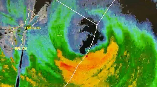
The typhoon’s centre passed over the northern tip of Guam on Wednesday evening, the National Weather Service said. It is the strongest storm to hit the territory of more than 150,000 people in decades.
Its maximum sustained winds remained at 140mph late on Wednesday, and it was forecast to intensify throughout the day Thursday, the weather service said.
Videos posted on social media showed fallen trees, a flipped pick-up truck, solar panels flying through the air, parts of a wall of a multi-storry hotel crumbling to the ground and exposing rebar, and storm surge and waves crashing through coastal reefs.
The early scope of the damage was difficult to ascertain, with power and internet failures making communication with the far-flung island difficult to impossible as the storm carved an excruciatingly slow path.
The storm was moving north west at 8mph on Wednesday with a slight increase in speed expected over the next day. It has been a slow-moving typhoon compared to others in the region that have moved upwards of 10-15mph, NWS Guam warning coordination meteorologist Landon Aydlett said.
Long-range forecasts place Mawar deep in the Philippine Sea, curving northward but staying northeast of the Philippines, Mr Aydlett said.
It is possible that the storm could regain super typhoon status, with maximum sustained winds of 150mph or greater, he said.
The storm clipped the far northern part of Guam, but otherwise it was in the channel between the island and its neighbour to the north, Rota, Mr Aydlett said.
“We have the peak conditions going on for a couple more hours. I think thrashing is the word I would use,” he said by phone.
“There are trees everywhere at this point. Daylight tomorrow is really going to be a shock to a lot of people.”


